
1891 Map Australia Queensland New S. Wales Victoria Tasmania Exploration Tracks - $12 - (Great Bend, KS)
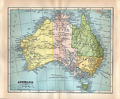
This is an authentic antique map of Australia including Northern Territory plus Queensland, New South Wales, Victoria and Tasmania. Distance is shown in British miles and geographical miles...exploration tracks are marked. This map is from a Dodd, Mead & Company encyclopedia with a Copyright date of 1891. The publish date is 1892 and this map is guaranteed authentic from that time--it is not a later reprint or copy of any kind. It is a tipped-in map with center fold as issued. The overall size is 11 5/8" x 9 3/4". The printed area is 10 1/8" x 8 3/8". It is in very good condition..the area that looks darker at center fold is just from shadowing. The margins have age toning which is darker around the edges. The map will lay flat. The coloring as shown in the first two pictures is pretty accurate--the third picture not so good but just to give you a closer look. Please zoom and enlarge the pictures for best detail. This will be placed in an archival protective sleeve and shipped in a sturdy cardboard reinforced envelope. Payment is due within three days after purchase and I ship the next business day after receiving payment. Additional paper items ship postage free--please wait for my combined invoice to pay. Thank you for looking.


ADVERTISEMENT
From ebay.com - 1 month ago