
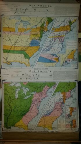
VINTAGE Pull Down School Map - Exploration and Colonization 1580-1750 - $99 - (Slingerlands, NY)
A rare original vintage pull down map circa 1966. From the Denoyer-Geppert Wesley Social Studies Series. This is a large map with overall dimensions of about 44" x 76". The bottom section is titled "Exploration and Colonization 1580-1750" and covers the following topics: 1. Early Explorers; 2. Early Colonial Settlements; 3. International Rivalries; 4. Growth of English Colonies; and, 5. Eastern Indians. The top half of the map is called "Colonial Grants" and covers the following topics: 1. Early Colonial Grants; 2. Colonial Consolidations; 3. Overlapping Claims and Controversies; and, 4. New England Confederation. A beautiful example of education from yesteryear. Still has lovely colors and clear lettering and labels. The map has a wood dowel on the bottom and it seems to be vinyl on canvas. The maps is on a working retracting mechanism mounted into a metal mounting frame -- See the last photograph. This map comes from a College in upstate New York. The Ebay shipping center will be used for overseas shipping and the buyer is responsible for all shipping from there and any duties. {File 1.WA-9/10} This map is guaranteed original. Feel free to ask any questions.


ADVERTISEMENT
From ebay.com - 1 month ago