
Map of Britain, by Collins Easy Route Planning Map - $6 - (White Salmon, WA)
Back to Search Results
Posted 1 month ago
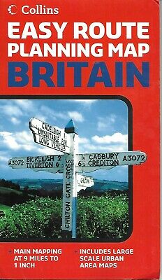
Map of Britain, by Collins Easy Route Planning Map Folded, indexed, road map of Britain, showing all major and many minor roads, cities and towns, at a scale of 1:555,000 (1 " to 9 miles). Map shows railways, castles, points of interest, monuments, national parks, and preserves, as well as a guide to the Restricted Motorway Junctions of Britain. Map includes large scale insets of Liverpool and Manchester, Birmingham, London, Edinburgh, Glasgow, Newcastle Upon Tyne, the Orknay Islands, and the Shetland Islands. Legend is in English. Map is printed on paper, and comes with a cardboard cover. Map measures approx. 40" x 36" when unfolded. Copyright 2006, ISBN 978-0007204205
ADVERTISEMENT
From ebay.com - 1 month ago