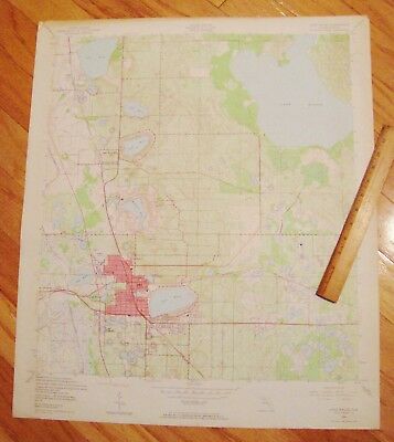
1952 LAKE WALES FLORIDA HUGE U.S. GEOLOGICAL SURVEY MAP 23" X 27" Orig'l XLNT - $13 - (Winter Haven, FL)
GORGEOUS, SCARCE, AUTHENTIC, ORIGINAL, VINTAGE, HUGE, 1952 U.S GEOLOGICAL SURVEY COLOR MAP OF LAKE WALES FLORIDA, dated 1952! See all 6 images including close-ups AND see the 12-inch ruler in images for size perspective! Measures a BIG 23" X 27" on quality paper, printed 1-side only! PROVIDES a highly detailed U.S. Geological Survey color map of the entire Lake Wales Quadrangle including cities, towns, and villages; town blocks; roads and streets; RAILROADS; lakes and/or other waterways; swamp areas; AND much more! With legend in lower right corner! NOT a reprint; NOT a reproduction; NOT a photo-copy; and NOT laser enhanced, digitally recreated, or any other type of phoney map - THIS is an authentic original U.S. Geological Survey map from 1952! NEVER FOLDED OR CREASED - HAS ALWAYS BEEN STORED FLAT - A RARE SURVIVOR - WOULD LOOK SPECTACULAR IF PROFESSIONALLY FRAMED AND MATTED - AND SHIPPED VIA POSTER TUBE - General light wear and soiling BUT THE COLORS REMAIN CRISP AND BRIGHT; has some light age-toning and/or dust soiling at edges; has some minor bumps, rubs, and/or tiny wrinkles at edges and corners; overall in very good+ to maybe approaching excellent VINTAGE condition! - CHECK OUR OTHER LISTINGS FOR MORE GREAT STUFF!

ADVERTISEMENT
From ebay.com - 1 month ago

