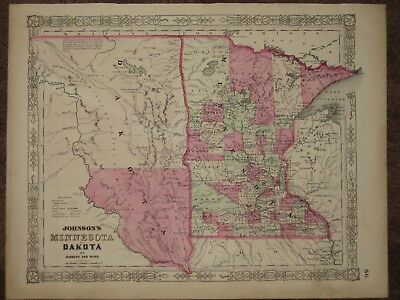
1863 DAKOTA TERRITORY MINNESOTA CIVIL WAR MAP Johnson Geography Atlas - $45 - (Pelham, AL)
An Original Antique HAND WATER COLORED Map of the DAKOTA TERRITORY and the State of MINNESOTA from Johnson and Ward's New Family Atlas, published 1863. This CIVIL WAR map shows the counties individually hand water colored. Published in 1863, this was one of the first Johnson maps with the "DOMINO BORDER". The eastern portion of the DAKOTA TERRITORY is shown as well as the recently admitted State of MINNESOTA. Only 1 railroad existed at the time connecting Minneapolis to St. Paul although several dozen proposed railroads and wagon roads are shown. In the DAKOTA TERRITORY only the proposed route of the Northern Pacific Railroad is shown and only and only Sioux Falls City and 4 other small villages existed in the extreme southeast of the Territory. An inscription at the upper left hand corner reads "The vast region of Prairies from Red River of the North and Mini Wakan L. to about the Gr. Bend of the Missouri R. is the Great Hunting and Fighting Ground of Dakota, Odjibwe, Assiniboin, Arikara, Minitarree, and other Nations". A rare map, because even this map would become obsolete within months as the borders of the Territories would continue to change. Beautiful original pastel colors. Map measures 14 by 18 inches. Guaranteed an original antique map, I do not sell reproductions of any kind. 100% satisfaction guaranteed! If you are unhappy with an item for ANY reason you can return it for a full refund. If you have a problem please email me before leaving feedback, I am VERY easy to work with.

ADVERTISEMENT
From ebay.com - 1 month ago

