
22 Results for Antiques for sale in Vandemere Nc - Classifieds

2 Solid Cherry by HARDEN Regency Empire Style Dining Arm Chairs Mid-Century. *** This listing has been changed to include BOTH Chairs. . Excellent used condition. Please look closely at all photos as I do my best to…
1 month ago on ebay.com
Lowery, Woodbury. THE LOWERY COLLECTION A DESCRIPTIVE LIST OF MAPS OF THE SPANISH POSSESSIONS WITHIN THE PRESENT LIMITS OF THE UNITED STATES, 1502-1820. Washington, D.C.: Government Printing Office, 1912. 567 pp., f…
1 month ago on ebay.com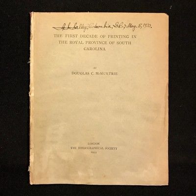
McMurtrie, Douglas Crawford. The First Decade of Printing in the Royal Province of South Carolina. London: The Bibliographical Society, 1933. 1 preliminary leaf, pages [425]-452, illustrations (facsimiles). Royal oc…
1 month ago on ebay.com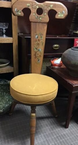
Unique Mid-Century 3 Legged Wood Chair Fabric Seat Danish Folk Style Three Legs . Great little estate find. I'm not a decor specialist, but based on the seat Corson and leg style, I'm thinking this is a 40's-50's Mo…
1 month ago on ebay.com
Winsor, Justin. THE KOHL COLLECTION OF MAPS RELATING TO AMERICA. Cambridge: Library of Harvard University, 1886. 70 pp. Text in double columns. First edition. Original printed wrappers. Library of Harvard University Bibliographical Contributions No. 19. Very good condition.…
1 month ago on ebay.com
> Stevens, Henry and Roland Tree. COMPARATIVE CARTOGRAPHY EXEMPLIFIED IN AN ANALYTICAL BIBLIOGRAPHICAL DESCRIPTION OF NEARLY ONE HUNDRED MAPS AND CHARTS OF THE AMERICAN CONTINENT PUBLISHED IN GREAT BRITAIN DURING TH…
1 month ago on ebay.com
Very good condition. One very small void in the glaze in the upper right hand side. Barely visible as framed. Back says : Craven Dunhill & Co., Jackfiel Salop 102 Tile size is 5 1/2" x 5 1/2". Framed in gold tone metal. Ready for hanging. Framed size is 6 1/4" x 6 1/4". Shipping cost quote is for US delivery only.…
1 month ago on ebay.com
Winsor, Justin. THE KOHL COLLECTION (NOW IN THE LIBRARY OF CONGRESS) OF MAPS RELATING TO AMERICA BY JUSTIN WINDSOR WITH INDEX BY PHILIP LEE PHILLIPS CHIEF, DIVISION OF MAPS AND CHARTS. Washington, D.C.: Government Printing Office, 1904. 189 pp. Second edition. Original cloth. Very good.…
1 month ago on ebay.com